Tuesday, July 26, 2022

Quiet Trails


Pathways, where another has traveled before, while many have not.  Leaving the vistas with the same appearance very near the same as the first. This pathway may be walked, hiked, snowshoed, cross-country-skied, or paddled as designated "Quiet Trails". Some "trails" are designated motorized or ridden by car, 4 - wheeler, or snowmobile.  Abide by the designations and take out of the trail only that which you brought in.


In this post, you'll find a listing of designated foot paths and water trails.  Motorized trails are listed in a separate post.  Enjoy the trail.

FOOT PATHS 

NORTH COUNTRY SCENIC TRAIL is a national trail that traverses eight states and 4,600 trail miles maintained by local chapters.  A portion, 16 miles, is routed through the Tahquamenon Falls State Park the balance in the eastern upper peninsula is maintained by the Shore-to-Shore North Country Trail Chapter with deep appreciation within the community.

NORTH COUNTRY SCENIC TRAIL M-123 to NAOMIKONG OVERLOOK, a section of the North Country Trail located in the Hiawatha National Forest, south of the Tahquamenon River mouth that follows the shoreline of Lake Superior's Whitefish Bay.  As a NCT designated trail identified with the familiar blue blaze, this portion of the trail as well as the balance of the eastern UP is maintained by the Hiawatha Shore-to-Shore Chapter.  You'll often find organized hikes with the group as well as opportunities to join the group in maintaining or blazing new trails.  

NORTH COUNTRY SCENIC TRAIL TAHQUA ROAD is one of my favorites and often hiked by the Hiawatha Shore-to-Shore Chapter members on January 1.  A trail head can be located along Tahqua Trail Road south of Paradise, just north of the Tahquamenon Falls State Park's roadside park north of the Tahquamenon River mouth.  This trail follows the shoreline of the Tahquamenon River and offers breathtaking vistas of the wilderness river.

MICHIGAN IRON BELLE TRAIL uses existing trails and traverses some 2,000 across the state from the Western tip of the Upper Peninsula to the Detroit.  Promoted as two routes, this one great trail is displayed by the Michigan DNR on their website.  A portion of this great trail moves through the Paradise region.

PARADISE PATHWAY: North Loop (3.2 Miles) The Paradise Pathway trail head is located just 1/4 mile west of the blinking light in Paradise on route M-123, the Tahquamenon Scenic Byway.  Paradise Pathway consists of three paths.  You'll find a local group of volunteers, Tahquamenon Country Pathways Association that maintains the Paradise Pathways.   Clearing brush and fallen debris and grooming them for snowshoe and cross-country skier alike. Paradise Pathways are within the Tahquamenon Falls State Park region.

PARADISE PATHWAY: North Ridge Loop (3.4 Miles) North indicates its location North of M-123.  The trail head parking lot is located south of M-123.  You'll find a map of these three loops at this link:  paradise_trail.pdf (state.mi.us)

PARADISE PATHWAY: South Loop (1.6 Miles) The shortest and yet most popular path, located south of the Tahquamenon Scenic Byway.  

TAHQUAMENON FALLS - Giant PinesLoop (3.8 Miles) Known for two specific giant white pine trees, hemlocks, bubbling streams, and wildlife, this is a popular cross-country ski trail.

TAHQUAMENON FALLS - Clark LakeLoo (5.2 Miles) Through pine forests with views of Clark loop begins at the parking lot on Clark Lake Road.  There are several areas of silver and green lichens, ferns, blueberries, jack pine uplands and moss-carpeted lowlands.  It is possible to connect with the Wilderness Loop from this trail.

TAHQUAMENON FALLS - WildernessLoop (7.0 Miles) Assessable to the North Country Trail, Clark Lake Loop or the Giant Pines Loop, this trail crosses through pine ridges, peat lands, and hold growth hemlock forests.    This trail is designated as one of the more difficult, primitive trails.

TAHQUAMENON FALLS - Nature Trail (0.5 Miles) a breath of fresh air in a short distance.  This trail is utilized in February for the park's lantern lit trails but in the summer months you'll find it blanked with ferns.

TAHQUAMENON FALLS - River Trail (4.0 Miles) This trail is one of the most popular in scenic trails in the park.  It traverses through American beech, sugar maple, eastern hemlock and yellow birch trees as you hike between da Falls (the Upper and Lower Tahquamenon Falls).  Due to roots and unlevel pathways, this trail can be challenging.

TAHQUAMENON FALLS - Emerson Foot Trail (1.0 Miles) At the time of this writing, this trail is in development phase, but it is ideal for birdwatching as the trail meanders along the banks of Tahquamenon Bay.

WATER TRAILS


LAKE SUPERIOR East Water Trail is a paddling trail from Grand Marais to Whitefish Point, to Lake Superior's South Shore.  Historically valued in the early times by native Americans, voyageurs, and early European explorers.

TAHQUAMENON RIVER is very nearly a wilderness river.  The Woods, Tahquamenon River Canoe and Kayak Rentals has been offering guided tours and paddling recommendations for years.  They offer short- and long-term excursions.  Remember kayaking on Lake Superior can be dangerous, even the most experienced in the area respects the quick swells that can develop seemingly out of nowhere.

MOTORIZED TRAILS 


Sometimes a person doesn't want to cover more ground in a short amount of time.  The Paradise area offers scenic driving routes, 4-wheeler options, and seasonal popular snowmobile routes.  Learn more about Motorized Trail Options at this link:  Motorized Trails 

PLACES TO STAY!

This information is brought to you by the Paradise Area Tourism Council and their members:   Curley's Paradise Motel, Magnuson Grand Lakefront ParadiseParadise Shores Cabins, and Vagabond Motel.  Sign up for our newsletter to stay current on activities in the area.

 * * * * * * * * * * * * * * * * * * * * * * * * * * * * * *
Like Us on Facebook      Join Us on Instagram      Join Us on Twitter      Experience Michigan's Paradise Website        

Thursday, July 21, 2022

Lighthouses


Sunday, August 7 is National Lighthouse Day!  The state of Michigan hosts more lighthouses than any other state, due in large part to the role of Lakes Superior, Michigan, and Huron.  According to Michigan Lighthouse Guide there are 129 beacons of light on the registers of such nautical data.  

In the Paradise area there are three conveniently located with incredible life-saving stories, scenes, and artifacts.  Paradise is located just north of the Tahquamenon River mouth on the Tahquamenon Scenic Byway (M-123) in the Upper Peninsula of Michigan.  We encourage you to take the entire family and spend some time at each location.  

Whitefish Point Light Station

Whitefish Point Light Station is located 10 miles north of Paradise on North Whitefish Point Road which connects to the Tahquamenon Scenic Byway at the blinking light in Paradise.  It is a privately owned and managed site by the Great Lakes Shipwreck Historical Society and the fully operating tower is a component of the Shipwreck Museum.  The present Whitefish Point Light tower was built under the authorization of U. S. President Abraham Lincoln in 1861 and has been offering safe pages to vessels entering Lake Superior from Whitefish Bay since 1849.  

The Shipwreck Museum offers information regarding shipwrecks, ship rescues, and shipwreck discoveries throughout the great lakes.  The complex is a series of restored buildings and carefully catalogued artifacts of the U. S. Life Savings services offered over the past 175+ years.   Freighters headed upbound from and downbound to the Soo Locks in Sault Ste. Marie, Michigan pass by the facility located on Whitefish Point with great frequency.  The museum is open May 1 through October 31, daily, 10 AM to 6 PM.  www.shipwreckmuseum.com


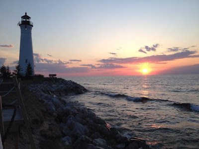
Crisp Point Light Courtesy David Piontek


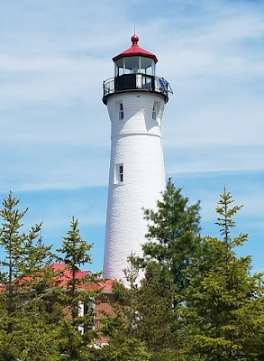
Crisp Point Light is located along the southern shoreline of Lake Superior between Whitefish Point and Grand Marais.  There is no direct, easy, or as the "crow flies" (14.5 miles) route to Crisp Point, built in 1875. But you will find County Road 500 intersecting with Tahquamenon Scenic Byway (M-123) just west of the entrance to Tahquamenon Falls State Park.  Their website includes specific directions and tips to locate the tower.   Crisp Point Light property is owned by Luce County and is managed by the Crisp Point Light Historical Society.  Boatman and former lighthouse keeper, Christopher Crisp is the namesake of this incredible facility that has been painstakingly restored through the efforts of many volunteers. 

Many lighthouses were established in remote proximities as they offered safe harbor to passing ships and Crisp Point provides that feeling when you approach the shoreline and take in the incredible, views along of Lake Superior.  The information center and restrooms are open usually from the end of May to mid-October, open daily from 10 AM to 6 PM.  Crisp Point Light Historical Society offers a lighthouse keeper volunteer program at their facility offering the couple or family an opportunity to manage the information facility and gift shop, answering questions, sharing the Christopher Crisp life-saving story.  Learn more information about this light and the opportunities therein at www.crisppointlight.org.


Point Iroquois Courtesy Janet Meeks 2018


Point Iroquois Lighthouse is located along the Saint Mary's River mouth and the entrance into Lake Superior's Whitefish Bay.  The Tahquamenon Scenic Byway (M-123) intersects with the Curlie - Lewis Memorial Highway which meanders along the southern shoreline of Whitefish Bay.  Point Iroquois Lighthouse is on this route, the property is owned by the U.S. National Forest Division and is currently managed by the Bay Mills Indian Community.  Point Iroquois was named referencing a 1662 between the Iroquois and Chippewa.  The Point Iroquois Light was first lit in 1857 in a 65-foot tower and was in service for 107 years.  Today the museum offers a collection of artifacts that tell the stories of the Anishinaabe, French Explorers, and lifesaving efforts of the lighthouse.  

On sight there is a museum that offers insight into the personal lives of the lighthouse keepers and their families and a gift shop.  Conventionally the museum is open in the summer months but may under the management of the Bay Mills Indian Community remain open in the winter months as well.  Museum hours are Tuesday through Saturday from 10 AM to 4:30 PM.  There is a handicap accessible walkway from the parking lot to the shoreline of the St. Mary's River.  The walkway offers benches, elevated walkways, and fabulous views of freighters headed up or downbound pass Point Iroquois.

Places to Stay!  

This information is brought to you by the Paradise Area Tourism Council and their members:   Curley's Paradise Motel,  Magnuson Grand Lakefront ParadiseParadise Shores Cabins, and  Vagabond Motel.  Sign up for our newsletter to stay current on activities in the area.

 * * * * * * * * * * * * * * * * * * * * * * * * * * * * * *
Like Us on Facebook      Join Us on Instagram      Join Us on Twitter      Experience Michigan's Paradise Website        

Tuesday, July 19, 2022

Museums


Facilities or groups dedicated to preserving a collection of objects deemed of lasting interest and value and dedicated to sharing the true story of an event, culture, of scientific or historical importance.  Wikipedia
In the Paradise area we are fortunate to have a number of museums with individuals passionate about their charge.   We encourage you to take some time to learn the complete story offered by these groups:  Great Lakes Shipwreck Historical Society, Crisp Point Light Historical Society, the Tahquamenon Logging Museum Advocates, Bay Mills Indian Community, and the Bay Mills-Brimley Historical Research Society.
Shipwreck Museum


Shipwreck Museum, identified as one of the top ten Mari-time museums in the world, is located at Whitefish Point, 10 miles north of Paradise.  Managed by the Great Lakes Shipwreck Historical Society and includes in its operations an active process in locating and identifying resting places of ships and lives lost along the Shipwreck Coast.   Located north of Paradise on North Whitefish Point Road, open May 1 through October 31, seven days a week, 10 AM to 6 PM.

Crisp Point Light


Crisp Point Lighthouse is located along the southern shores of Lake Superior, 38 miles northwest of Paradise.   After the long winding drive to the light, the visitor's building offers souvenirs and a view of Lake Superior in this remote, phenomenal location of Crisp Point.  The story here is a boatman named Christopher Crisp and the U.S. Lifesaving Services.  Many lighthouse facilities were in remote regions of the world.  Crisp Point is no different, but the experience of traveling to Crisp Point is physical immersion into that reality.  Open end of May to October, the visitor's center is open 10 AM to 6 PM


Tahquamenon Logging Museum

Tahquamenon Logging Museum offers the visitor insight into the logging industry and history of a local industry that rebuilt the city of Chicago after its great fire.  Look at the tools and culture back in the day and learn how the industry has transformed to renew trees in the forests of the upper peninsula.  Located along the Tahquamenon River, 37 miles southwest of Paradise, join in one of their Lumberjack breakfasts, or summer music concerts and you'll capture the experience of their story.  The museum is open seven days a week, 10 AM to 5 PM beginning Memorial Day weekend through the summer months.

 
Point Iroquois Lighthouse


Point Iroquois Lighthouse is dedicated to a major battle in 1662 fought by Iroquois and Chippewa.  Beginning in June 2022, the Bay Mills Indian Community assumed management of the lighthouse in cooperation with the Hiawatha National Forest.  The Bay Mills Indian Community can tell its story and share the Anishinaabe history, cultural information, and artifacts at the lighthouse.  Located along the Curley Lewis Scenic Byway, 36 miles southeast of Paradise, offers a boardwalk, handicap accessible to the shoreline of the St. Mary's River offering a breathtaking view of freighters traveling up and downbound.


Wheels of History Museum


Wheels of History shares the story of early life in the Brimley area and eastern upper peninsula of Michigan.  It includes stories of the mills, trains, early phones, logging, fishing, one-room schools, Great Lakes ships, CCC Camp Raco, cemetery and veteran listings and local family history.  Located in Brimley, 44 miles southeast of Paradise.   The Museum is open seasonally mid-May to mid-Oct. from Noon to 5 PM Fri-Mon.  

Places to Stay! 

This information is brought to you by the Paradise Area Tourism Council and their members:   Curley's Paradise Motel,  Magnuson Grand Lakefront ParadiseParadise Shores Cabins, and  Vagabond Motel.  Sign up for our newsletter to stay current on activities in the area.

 * * * * * * * * * * * * * * * * * * * * * * * * * * * * * *
Like Us on Facebook      Join Us on Instagram      Join Us on Twitter      Experience Michigan's Paradise Website